Elevation: 5900′ Calories Burned: approx. 2000 Restrooms: At Laguna Mtn. Lodge 4 miles south.
Driving Directions: From the I-5, I-15, and state route 67, travel east on I-8 and exit on the Sunrise Highway off-ramp. Turn left, and follow the sunrise highway up through the forest, past the village at Mt. Laguna, and park at the Penny Pines Trailhead. Parking is free.
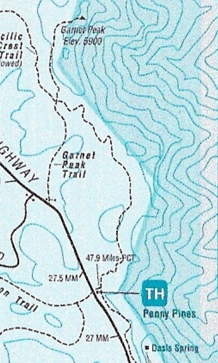
Garnet Peak Map
I love doing first-time hikes and Garnet is one I’ve wanted to do for a while now. Located out in the Beautiful Laguna Mountains Cleveland National Forest area, half the fun of this hike is getting there driving through the Curvy Sunrise Mountainous Hwy., through Pine Valley which is comprised of Jeffrey Pines, gorgeous mountain scenery and at every tune views to die for, literally, so drive safe.
You will pass the Laguna Lodge on the left, stop here to use the restroom and last-minute snacks and or liquids. Continue on about 4 miles and the trailhead starts to Penny Pines is on the right between the 27.0 and 27.5-mile marker. There is plenty of parking which is free with no need for an adventure pass.
The Penny Pines trail is the middle version of hiking Garnet Peak, as there are 10.4 (Pioneer mail) and 2.5-mile (Sunrise Highway 0.1 miles south of Mile Marker 28, near Deer Lake Park Road.), roundtrip trails.
I like this hike because the 4.7 miles offers a challenge, is not overwhelming and gives you enough trail to appreciate everything that the 10.4-mile trail offers and makes the drive out to the Laguna Mountains and Pine Valley worth your time and energy.
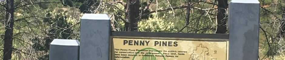
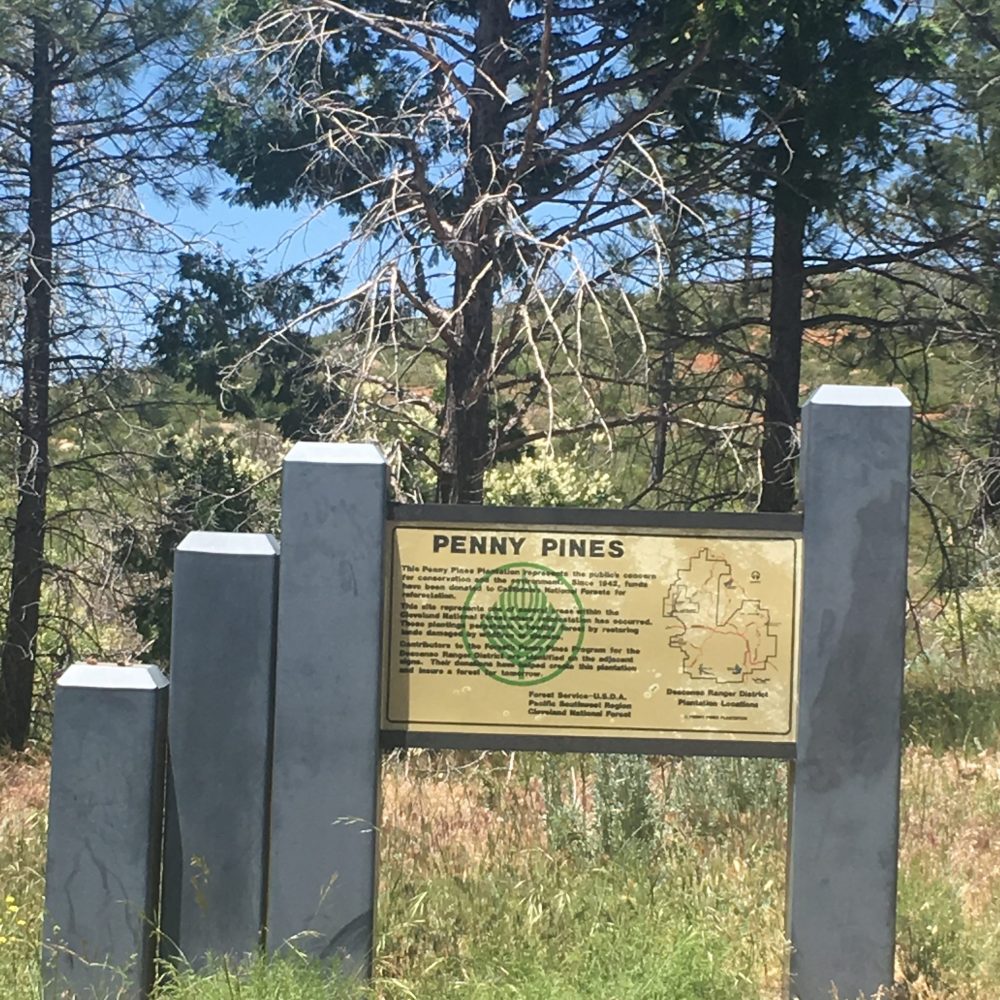
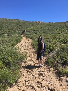
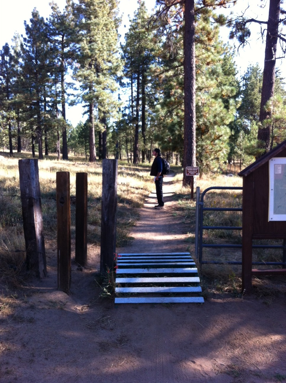
Penny Pines trailhead Start
The trailhead is well marked with a large Penny Pines trailhead sign, you will see the Penny Pines Information board and the trailhead start. Pass by the sign onto the trail leading you to Garnet Peak along the Pacific Crest Trail. PCT blue shield markers denote the Pacific Crest Trail. Head northeast on the trail and you are on your way to the beautiful surrounding views of the desert before you and the rocky green landscaped mountain scenery all about you.
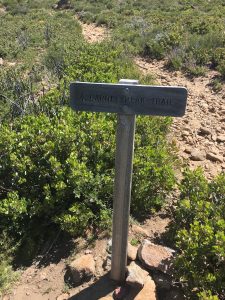
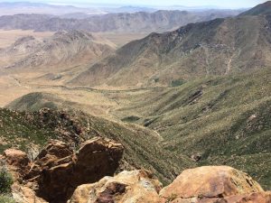
The trail along the PCT will meander north heading for the Garnet Peak junction of the PCT. Once you get to this point you will see a Garnet Peak Trail sign at mile mark approx. 1.85 miles, turn right and head east to Garnet Peak. You will start to see the Peak as you again angle north, don’t be intimidated by the Peak, it’s more intimidating looking than it is. You will come to a Garnet Peak sign, go right and head up the steep rocky trail to the Peak. you are now less than .50 mile from the boulder covered peak.
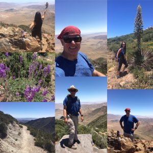
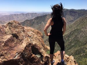
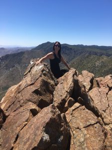
The last trek of this hike, you do some bouldering to the top. Take your time, before you know it you will have summited the beautiful peak of Garnet. Although the Peak is small, there are plenty of places to sit, rehydrate, eat and take in the vast beauty that unfolds before you; the desert floor below, the green covered mountains all around and the trail you left behind all enrich this beautiful visual experience. I love the Peaks!
The journey back is the same route and the 2.35 miles back are easy ones. I feel an added bonus to this hike is that the trail back, although of course the same trail, offers yet another variance to seeing the same you saw on the ascent yet a lot of what you did not see, again making this a totally fulfilling, challenging accomplishment of hiking Garnet Peak.
and the Flag at the Peak!
This is a must-do for any serious or not so serious hiker in San Diego County. You have a choice of 3 routes to get to Garnet Peak, each for every level of hiker. Also, the views at the Peak, as well as along the trail are breathtaking and I’d seriously rank as top5 views of any hike in San Diego County.
Have fun, be safe and as always; Hike with a partner, respect your limits, respect your partners limits, bring morewater than you need and be mindful where you step (snakes and rocks are plentiful on this hike) , one step at a time………..
After the Hike go to Alpine Beer Company for a well-deserved meal, drink and or both.
If you are looking for a hike that offers you three trails in one each offering its own unique scenery, challenge and physical make-up than the Big Laguna Loop hike is for you. Located in the Laguna Mountains roughly one hours drive from downtown San Diego on the Sunrise Highway, this recreational area has something for everyone, especially those of us who love to hike. However if you are an avid trail rider and or runner this area has the trail for you.
As the Big Laguna Loop Trail map shows you can get on the Big Laguna Loop at various points however, we began at the Sunset Trail trail-head, which is just opposite the Meadows Information Center near mile marker 19 on Sunrise Highway, S1. To get to the Trail-head: From Interstate 8 heading east, exit at Sunrise Highway, S1, heading north. In about 5.6 miles from the freeway, near mile marker 19.1, park along the wide shoulder near the Meadow Information Center. Make sure you have a California Adventure pass if you choose to park right near the trailhead start, which I recommend. Look for the fenced area and information board along with the small steel “bridge that welcomes you to the trail and off you go! If you are using the map suggested here on the link, keep in mind that the trail that we choose, the Sunset Trail, is not outlined in highliter as shown on the map at the link, however you get the idea!
Sunrise Trailhead start
The start of the trail winds through a forest of pines and various other tree types. The trail is compacted earth dotted with occasional rock. Although the trail dips and climbs on this portion of the hike you are never dipping below 5400 feet of elevation nor rising to more than 5900 feet the entire time you are on the hike and the three trails I am mentioning here. The views seem to go on forever as you are surrounded by green, trees and off in the distance gorgeous mountain views.
Breathtaking views all around!
The forested feel of this hike gives way to a mountainous terrain and as the trail becomes rockier it weaves through boulders and drops a couple of hundred feet down.
PInes, mountains and boulders
About 1.5 miles from the trail head, you come onto the lower edge of the huge Laguna Meadow and that little pond, Water of the Woods (sometimes referred to as Lake of the Woods).
Water of the Woods
According to a detailed map near the trail-head, Water of the Woods is fed by Agua Dulce Creek and ultimately connects to Big Laguna Lake and Little Laguna Lake, both to the east of Sunset Trail. The views from this point on the trail are one of my favorite. The distance pines flank the vast area of Laguna Meadow, all this topped by a semingly endless blue sky. In fact if you didnt know you were in the middle of the Laguna Mountains, you could be Big Sky country in Montana! At this point in the hike you will turn left at the marker sign that will lead you continuing onto the Sunset Trail. The rocks are big and the Jeffrey Pines are numerous as this trail dips and climbs steadily through a forest of different vegetation and open trail.
Big Laguna Meadow
Continue about three more miles on Sunset Trail, which connects at 4.6 miles to the northern edge of Big Laguna Trail. This section of the trail offers a wide open view of Laguna Meadow to the right and the contiued trail dotted with Jeffery Pines, brush and rock. The trail continues like this for about another mile as you lose site of the meadow and the trail narrows throough thick vegetation untill you get to an old iron gate that marks this section of the trails end. Soon you will come to the Sunrise Highway S1, crossing which will lead you to the Pacific Crest Trail (PCT). The trail is marked but be alert as you may pass the trail entrance on the immediate right.
Beginning of PCT
The trail parallels Sunrise Highway so your instincts will kick in and guide you. The PCT piece of the Big Laguna Loop offers a whole different perspective of the area and immediately takes on a desert feel, not only in temperature, but scenery and ruggedness as well. Off to the distant east beautiful vistas lead to the beginning of the Anza Borrego Desert floor. The trail’s composition changes to a more desert mix of rock, red dirt and is uneven. The approaching Manzanita Grove offers a sea of green amidst this arid part of the trail. The trail winds and climbs and in my opinion offers the more challenging part of the Big Laguna Loop.
On the PCT
As you continue on the PCT, which is well marked with sign posts, your goal is to get to Foster Point. Not only does this section of the trail give you a good view but it alos signifies that soon you will be leaving the PCT and heading back towards the Big Laguna Meadow and trail. Within 100 feet you will come to a trail junction and you will want to head southwest or right on this spur of the trail. Continue hiking to the Sieera Club lodge and retrerat area on what is now a service road. THis road will junction with the Sunrise Highway, which you will cross to the right and at any point turn into the Al Bahr Shriners Camp. Follow the road to the left, you will come to picnic tables on the left hand side of the road, which is where my son and I ate lunch. This marks about the 7.5 mile part of the loop with a little more than 3 miles to go on the hike. Continue on into the Horse Heaven Group Camp and from here head to the right along the asphalt road. You will see a left segment branch off and a landmark is the original rangers station on the right hand side of the road. Continue past the restrooms to a large information board which has a large map of the meadow to help guide you back into the meadow and towards Big Laguna Lake. You want to head towards the southern tip of Big Laguna Lake, there is a spur of the trail that sits on a raised ridge that crosses over just south of the edge of Big Laguna Lake, at spurs end turn left and follow the Big Laguna Trail back towards the “pond” or the Lake of the Woods. Hiking along the northern edge of the “Pond” will lead you back into the Sunset Trail and the original starting trail of this hike. You will now head back to the trailhead start and the Sunrise Highway area where you parked.
This was a challenging hike in that it offers you enough diversity of trail, scenery, and distance to make it my second favorite strenuous hike after the Mt San Antonio (Baldy) hike. A word of advice or suggestion would be on this hike to make sure you bring a map of the area and trails. Although the Big Laguna Loop is well marked there are many spurs on this hike to divert you. The good news is that the beautiful meadow layed in the middle of this hike oofers you a good landmark as to where you are and where you need to go. Follow the map and you wil be good!
Great Hike, Have Fun!
Distance: 10.5 miles
Date and Time: Saturday Sept. 3, 2012 9:40AM-2:30PM